When we left Dawson City, we traveled a part of the Yukon we had not seen on the way north to Alaska; then we had traveled to Tok. But on the return trip we braved the Top of the World Highway from Chicken to Dawson City, as already reported. The scenery along the new route, as nearly all the scenery in this part of the country was sensational. If a body stopped to take a picture at each spot that made him drop his jaw in awe, the road would never get traveled. So just a few shots to give you the jist. Besides, with roads like these there are few shoulders and even fewer places to stop for a photo opportunity. Most amazing spots you just cruise on by, saying, oh, I wish everyone could see this!!!


One thing in particular that caught my fancy was the white layer just below the thin layer of top soil along this part of the run. It's actually a very thin layer of volcanic ash put out an awfully long time ago, but still everywhere to see. The rounded mounds of the hills along the road represent the leading edge of a lava flow that stopped right at the point where the highway now runs. It's all very strange to drive past until you read about what took place and then it all makes sense. It's hard to think of such a cold place with so much ice and snow and sub freezing temperatures formerly being an area of intense volcanic activity- as Walter Cronkite always used to say "And that's the way it is..." Of course if you'll click on the picture to enlarge it, you'll see the ash layer much easier.

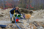
Back at Whitehorse, we again stopped by the salmon fish ladder, which was closed when we passed this way in the Spring. This time it was closed for the season, but the water level was near flood stages and God help any salmon who still needed to get up stream a bit late- tough going to say the least! From Whitehorse on to the Cassiar Highway, we traveled the same section of road we had taken north earlier in the year.

At the final junction in our overlap return run, we stayed at the head of the Cassiar Highway at a place called the Bay Nugget Campground. The wifi center was in an unheated building called the "Best Little Ore House." Cute...but cold. Really cold. No I mean really, really cold. Almost froze my little nuggets!

Oh, those girls and their burls!

The Cassiar Highway (who ever named it a highway, anyhow???) is beautiful, but it's a whole lot more like a trail than it is a highway. Isn't it implied that on a highway you can go at least 50 mph? That would be an act of suicide on this highway. Either the vehicle you are driving would launch off the road or it would fall to pieces in the middle of the road. As there is nothing and no one to help along the way- neither of these would seem to be a very good option. We thought we would tackle the biggest challenge of the trip by driving the Top of the World Highway. Seems like the Cassiar is the evil twin sister. Don't get me wrong! The drive is beautiful and loaded with historical importance. It's just that it is a dangerous road to drive unless you go slow and be careful. It seems like it takes a road from Hell to give you a glimpse of Heaven on Earth. So be it.

There are Dry Creeks everywhere. They aren't! For the most part, dry, that is, but they look the part.

We pulled in at Jade City. Here they mine the jade, design the jade, carve the jade, slice the jade, and sell the jade any way you want it- token, piece, slab, ton. A full 75% of the world's quality jade comes from right here in the Cassiar Mountains. Same is true of high grade Asbestos. And the largest gold nugget ever found here weighed in at 73 ounces. (I'm pretty sure I would only need one like that!)

Yes, the scenery was magnificent, but what made it even better was the fact that we had the roadway pretty much to ourselves. I stopped right in the middle of the road to take this picture. Our whole experience here in the north country has been like an RV ad in a magazine. Us, the road, the mountains, the lakes- just us! Not relishing the idea of going back to non stop traffic.

We pulled over for lunch by one of the hundreds of lakes along the road. Sure enough, Mrs. Moose was dining at the same lake. You'll see her in the back of the lake in the tall grass. There was an arctic fox playing along the road as well. Beautiful!

So, yes, there are large and nasty gravel sections of the highway. Pot holes. Washboards. No shoulders. Soft shoulders. A detour you say? Well shut my mouth and hold my breath! What you can't see is that this temporary go around is very very soft and the downhill experience, should it give out, would have been, shall we say, exhilarating. You can see the workers taking bets on whether any big rigs would make it without collapsing the detour. Places like this were the only spots where traffic backed up at all and you knew there were others using the road.

This is the view to the lake out my side window at the computer desk at the end of the day at Shadow Mountain Camp. There are a whopping three campers in the whole camp tonight. It's late in the season by north standards. Most people head home after the 4th of July it seems. Not us. We're ringing every drop out of this trip. This is the only road I have ever been on where the road conditions (and terms of passage) are posted every so many miles. On the sign: Road (open or closed) Times closed. Time Open. Avalanche? Rock Slide? Etc. I have no idea what happens if the road closes when we are smack dab in the middle. We'll just have to see.


 One thing in particular that caught my fancy was the white layer just below the thin layer of top soil along this part of the run. It's actually a very thin layer of volcanic ash put out an awfully long time ago, but still everywhere to see. The rounded mounds of the hills along the road represent the leading edge of a lava flow that stopped right at the point where the highway now runs. It's all very strange to drive past until you read about what took place and then it all makes sense. It's hard to think of such a cold place with so much ice and snow and sub freezing temperatures formerly being an area of intense volcanic activity- as Walter Cronkite always used to say "And that's the way it is..." Of course if you'll click on the picture to enlarge it, you'll see the ash layer much easier.
 Back at Whitehorse, we again stopped by the salmon fish ladder, which was closed when we passed this way in the Spring. This time it was closed for the season, but the water level was near flood stages and God help any salmon who still needed to get up stream a bit late- tough going to say the least! From Whitehorse on to the Cassiar Highway, we traveled the same section of road we had taken north earlier in the year.
 At the final junction in our overlap return run, we stayed at the head of the Cassiar Highway at a place called the Bay Nugget Campground. The wifi center was in an unheated building called the "Best Little Ore House." Cute...but cold. Really cold. No I mean really, really cold. Almost froze my little nuggets!
 Oh, those girls and their burls!
 The Cassiar Highway (who ever named it a highway, anyhow???) is beautiful, but it's a whole lot more like a trail than it is a highway. Isn't it implied that on a highway you can go at least 50 mph? That would be an act of suicide on this highway. Either the vehicle you are driving would launch off the road or it would fall to pieces in the middle of the road. As there is nothing and no one to help along the way- neither of these would seem to be a very good option. We thought we would tackle the biggest challenge of the trip by driving the Top of the World Highway. Seems like the Cassiar is the evil twin sister. Don't get me wrong! The drive is beautiful and loaded with historical importance. It's just that it is a dangerous road to drive unless you go slow and be careful. It seems like it takes a road from Hell to give you a glimpse of Heaven on Earth. So be it.
 There are Dry Creeks everywhere. They aren't! For the most part, dry, that is, but they look the part.
 We pulled in at Jade City. Here they mine the jade, design the jade, carve the jade, slice the jade, and sell the jade any way you want it- token, piece, slab, ton. A full 75% of the world's quality jade comes from right here in the Cassiar Mountains. Same is true of high grade Asbestos. And the largest gold nugget ever found here weighed in at 73 ounces. (I'm pretty sure I would only need one like that!)
 Yes, the scenery was magnificent, but what made it even better was the fact that we had the roadway pretty much to ourselves. I stopped right in the middle of the road to take this picture. Our whole experience here in the north country has been like an RV ad in a magazine. Us, the road, the mountains, the lakes- just us! Not relishing the idea of going back to non stop traffic.
 We pulled over for lunch by one of the hundreds of lakes along the road. Sure enough, Mrs. Moose was dining at the same lake. You'll see her in the back of the lake in the tall grass. There was an arctic fox playing along the road as well. Beautiful!
 So, yes, there are large and nasty gravel sections of the highway. Pot holes. Washboards. No shoulders. Soft shoulders. A detour you say? Well shut my mouth and hold my breath! What you can't see is that this temporary go around is very very soft and the downhill experience, should it give out, would have been, shall we say, exhilarating. You can see the workers taking bets on whether any big rigs would make it without collapsing the detour. Places like this were the only spots where traffic backed up at all and you knew there were others using the road.
 This is the view to the lake out my side window at the computer desk at the end of the day at Shadow Mountain Camp. There are a whopping three campers in the whole camp tonight. It's late in the season by north standards. Most people head home after the 4th of July it seems. Not us. We're ringing every drop out of this trip. This is the only road I have ever been on where the road conditions (and terms of passage) are posted every so many miles. On the sign: Road (open or closed) Times closed. Time Open. Avalanche? Rock Slide? Etc. I have no idea what happens if the road closes when we are smack dab in the middle. We'll just have to see.


No comments:
Post a Comment