We take to the road full time in our 43' Newmar DUTCHSTAR and you get to come along for the trip- all expenses paid!
Monday, June 4, 2012
Hogback: Utah Scenic Byway 12
One hundred sixty miles round trip more or less. Non-stop spectacular scenery, much of it awe-inspiring, that changes every mile or so from one look to another. And finally punctuated by "the hogback" a ridge road with nothing but air and a drop off (and of course scenery) to either side. One hundred and fifty-nine and a half miles of relaxing, spectacular travel which turns into a half mile of heart stopping, blood pulsing, air gulping, steering wheel gripping, I'm-goona-die-if-the-wind-blows-now terror. Yea. That about sums it up. Oh. And that is on the way to Boulder, Utah from Bryce; then you gotta turn around and do it all again in the opposite direction. It's all true- but I wouldn't have missed it for the world. The experiencing of this road is the reason the road itself is a stand alone destination. Visitors come from all over to drive this perhaps the most beautiful of scenic byways in America. It was great. You should try it for yourself. But check the weather first. Because a windy day or a snow day or a freezing rain day? Listen to your Godfather: Forget about it!!!
A word about the pics. Tried to do just a random sample of what we saw. Tried to get the things we could get when we could pull over- many places you cannot. Also tried our first ever video clip for the blog, and while the fact that it is our first will be obvious and the sound terrible, I'm gonna include it anyhow (if I can figure out how to get it embedded) just to bring back the memory of that last half mile stretch or so.
In this shot, taken by telephoto lens, there are two Pueblo Indian made structures (a granary) about half way up the face of a cliff. To the eye, they appear like little tiny rock variations, but in actuality both structures are about the size of a person. Getting a handle on the scale of things in this landscape is very difficult. You will see another shot or two in the slide show.
Here, Marilyn takes a break after a strenuous rock climbing mission. At these altitudes, often 7 to 9 thousand feet, most activity places extra strain. Even a short hike, especially an up or down hill one, can take your breath away. Watch the slide show to see Marilyn's climbing adventure!
Well I can't seem to post our video to blogger so I've borrowed a you tube clip that looks alot like ours only ours was considerably longer. Until I can figure this thing out, I'll just feature this with end links to more of the same...
I've had a great life so far! I've been a lifeguard, a teacher, a dive master, a retail business owner, a technical writer, a landscaper, a property manager and now, saints preserve, a blogger. I've lived in PA, ME, FL and Roatan, Honduras. Now I'm on a tour of the US of A in a motorcoach with my incredible wife, Marilyn, and the memory of our way cool dogs, Abby and Carly. And with any luck at all, this is just the beginning...
Just A Note: We lost our dear traveling companion and Wonderdog Abby back in July of 2010. Just don't have the will to take her presence down since she still travels with us in our hearts and minds every which way we go....her sister Carly departed before our tour began, but she rides "shotgun" none-the-less.
Little Stevie's Corner
View To Arizona And Beyond in a larger map
This is a "live" map. You can click on the map tacks to see where we have been, are, or will be in the future. The plain markers are future destinations. The markers with the black dot in them are places where we either have been or are now. You can find out the dates of arrival (hopefully), campground name, and perhaps pictures and other info as the map develops. Give it a try! This map is currently in the "planning and development stage." Previous trip maps may be viewed and accessed below.... some of our earlier trips were not blog-mapped.
BUT: For those of you who just plain want to know where we are right here right now, just find the BIG RED MAP TACK!!!!
The Real US
Crossing Resurrection Creek, Hope, Alaska
The Which Way Do I Go Trip
View WHICH WAY DO I GO??? in a larger map
WHICH WAY DO I GO???
Usually there is a plan. A definite plan. But things are a bit up in the air right now, so no telling which way we will head or when.....
This is a "live" map. You can click on the map tacks to see where we have been, are, or will be in the future. The plain markers are future destinations. The markers with the black dot in them are places where we either have been or are now. You can find out the dates of arrival (hopefully), campground name, and perhaps pictures and other info as the map develops. Give it a try! This map is currently in the "planning and development stage." Previous trip maps may be viewed and accessed below.... some of our earlier trips were not blog-mapped.
PHOTO INSTRUCTIONS
In order to fully appreciate any still photo, you can enlarge it by clicking on it. Then click the Back Arrow to return to the blog.
If you find that a slide show moves too fast for you to enjoy the pictures, clicking on an active show will take you to the web album from which the slide show is generated. You can then arrow left or right to view the show one slide at a time. Take your time. No hurry!
Abby checks out a shell that SHE found! Click this photo to see a lot more pictures of me and my friends...
ABBY'S SIDE WINDOW: Gold Prospecting Pupper!
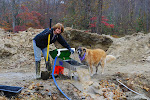
I'm helping check out the highbanker at the gold camp in Vein Mountain. It makes a good drinking fountain, too! Click on this picture to see the web album with more pictures of prospecting North Carolina
Visited States
Counting Down the Number of States Still To Visit: 0 - Any state you can't drive to shouldn't count!!!
Our friends at Google who host this blog organize the posts into groups of ten for the purpose of scrolling down through the most recent posts. Beyond that, they organize and store the posts monthly and annually. To view older entries click on the year and/or month that you wish to go back and read. For example, if you wish to read about our great Alaskan adventure, click on the arrow in front of "2007" to open the drop down 2007 calendar, then open each month in turn - May, June, July, August, and September.
Readers are welcome to send their comments on posts if they so desire. We "almost always" love hearing from you....To do so, just click on the "comments" link at the end of each individual post, then type your comment in the widow that opens for this purpose. You have the option of sending the comment anonymously and, again, you are welcome to use that feature. BUT- we really like to know who is reading and commenting, so don't be shy, feel free to give us your name- as you have that option open as well. Sometimes we get kind feedback and sometimes additional good info; occasionally a correction, maybe even a question. It would be nice to know who to thank and/or who to respond to. Keep in mind we are not able to reply directly to comments, no matter who they come in from; there is no reply path provided through Google. If necessary, I will try to add a comment myself to respond if I think it will be helpful. Thanks for your input!
IF you wish to establish direct contact with us, you may send your comment or question through the "comment" section and provide me with your e mail address in the text window. NOTE: I will NOT intentionally publish any comments that include your e mail address!


1 comment:
Enjoyed the slide show. I'm definitely doing this route next time in Utah.
Post a Comment