
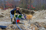
 Below is the shot from as close as we could get with the tide at this level. Though already down quite a bit- it will go much lower....much lower.
 Marilyn dwarfs at the mouth of the largest of the caves at low tide...
 The next, and our only full day here, the weather retreated to heavy fog and rain. That meant that the incredible vistas of the Fundy Trail would elude us. Still, there are things to see and do along the trail, no matter what the weather so we set out to do that. The stairs to the falls were so steep, they are actually a type of suspension bridge- 4 x 4's strung along a heavy wire cable, flexing all the way down and all the way back up. My legs hurt when I got back to the car!
 But as everything else here, the sight was worth whatever work it took to see it.
 There is a sub trail that hikes you in to the sea captains family burial plots. I had the feeling we were walking in the woods to no-where, but eventually we came upon a number of picket fence-enclosed cemetery plots with tombstones dating way back. We had the trail to ourselves on this day and it was a nice experience.
 Back on the trail, the fog and rain were not letting up. Once in a great while, like below, we caught a glimpse of some of the intended views. But as a rule, the fog won the day and hid its coastal booty from view of the lens.
 The river flows into the bay at the end of the trail at the interpretive center. We had some limited visibility here again.
 I took a picture of this boat floating when we started the trail. When we came back out, it, and all of the other boats in the protected harbor, was high and dry.
 And here is my sign of the day: Like much of the road signage here in New Brunswick, instruction is given in both English and French. This sign advised of a steep (14% is VERY steep) decline going down to the interpretive center. My "French" is nearly non-existent, so if this is a full translation- all well and good. But it looks more like English speaking drivers should test their brakes, and French speaking drivers should verify that they know who their friends really are before heading down the hill.... Ya think?
And finally for now a slide show from our low tide excursion to the sea caves on the Bay of Fundy:


No comments:
Post a Comment